Cadmapper & 6 Alternatives (Some are Free)

Working with map and terrain data in CAD can be useful for a myriad of things. Check out Cadmapper and alternatives! Some are even free.
The amount of geospatial data available on the internet is colossal. There are currently over 6,700 active satellites orbiting our planet and almost 1,200 of them are used solely for observation and data gathering.
This data serves multiple purposes besides searching for your own house on Google Earth. For one, civil construction relies on accurate site and topological information, from the smallest projects to more ambitious urban planning tasks.
On a less professional side, creatives have also played around with the geospatial data that is freely available. You’ve probably seen 3D printed maps and landscapes at some point, be it for educational purposes, cool decoration pieces, or even in celebration of a challenging hike.
In this article, we’ve selected eight tools used by both hobbyists and professionals to make the most of the geographic and map data available online. All the programs and websites in this list can generate CAD-editable files in 2D or 3D, including some free options.
If you create a fantastic model of your hometown but you don’t have the means to print it yourself, try Craftcloud. That way, you can handle the local knowledge, and leave the printing to the professionals!

Equator
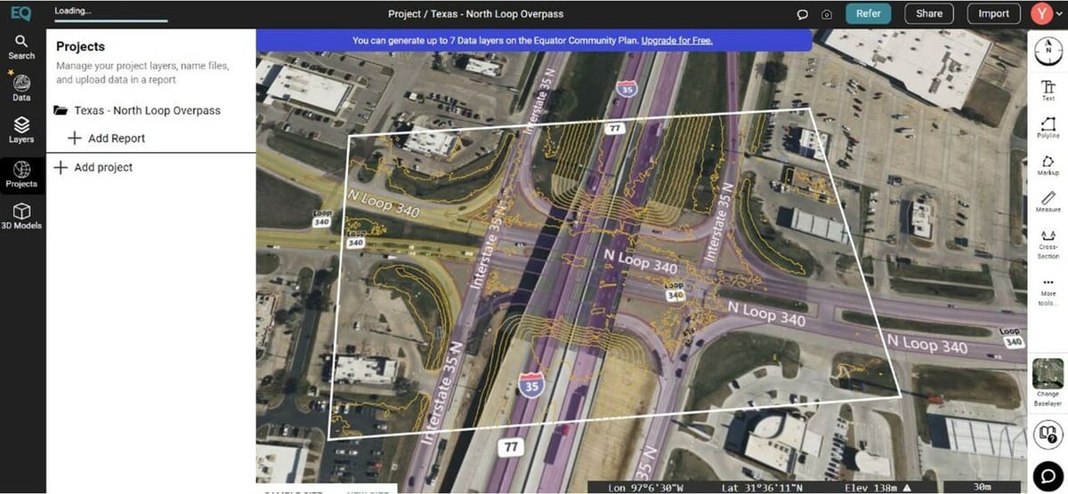
Equator is a state-of-the-art mapping and design software that was developed to improve communication and project management for design firms. Users can access different types of maps that are useful for planning and designing purposes.
It’s possible to extract topographic maps, street maps, land use maps, satellite imagery maps, and even geospatial data maps. The software also has a variety of information layers in order to enhance and highlight different aspects of geographical context. It comes with all the natural features, point of interest markings, and land zoning features well.
The program has a huge library of design assets at its disposal, including high-quality lidar datasets converted to contours, digital elevation models (DEMs), as well as pre-built templates with a variety of materials, textures, and furnishing models. These tools can be used to create custom maps, speeding up the design process and helping you quickly produce stunning visualizations.
Equator has a wide range of file-sharing options. Designers may easily import and export their files thanks to effortless integration with well-known design programs like AutoCAD, SketchUp, and Revit, eliminating the need for time-consuming manual transfers.
- Types: 2D and 3D
- Export options: DWG, PNG, STL, SHP, LAZ, TIF, OBJ, RAW, among others
- Price: Free up to seven exports, subscriptions range from $30 to around $200 per month
OpenStreetMap
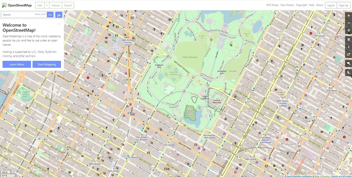
OpenStreetMap is a wiki-style world map fully independent of Google Maps. Created in 2004, the idea behind the project is to provide free geospatial data for anybody, from cartographers to programmers and activists.
Although only in 2D, OpenStreetMap offers different map layers like public transport and user-shared information like notes and GPS trace data.
The tool is entirely web-based, but edited maps can either be shared online or exported as images. This includes formats like SVG and PDF that can be further worked on with image editing software or CAD programs.
- Type: 2D map
- Export options: PNG, JPEG, SVG, PDF
- Price: Free
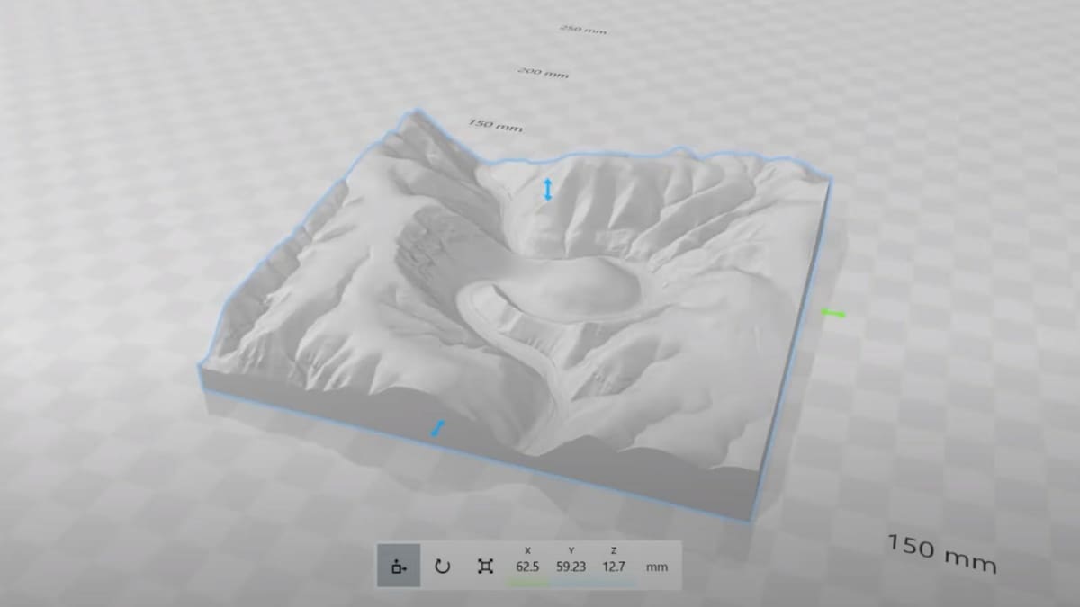
TouchTerrain
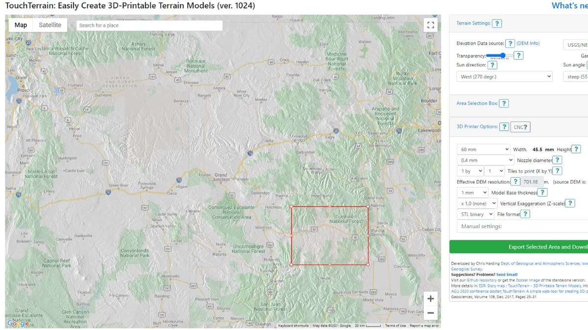
Developed by two geologists at Iowa State University, TouchTerrain is an online tool that generates terrain model files specifically for 3D printing.
It was created as a teaching tool for students to better understand complex landscapes and geographic formations inside the classroom. 3D printed terrain tiles are key visual aids for learning that provide much more perspective than 2D images in books.
TouchTerrain is free and relatively easy to use. The export settings include some 3D printing parameters like nozzle diameter, and formats are limited to STL and GeoTiff.
And as an alternative, Terrain2STL is a very similar tool but with a simpler UI but slightly fewer options for exporting the 3D models. Still, it’s very reliable and a popular option among hobbyists.
- Type: 3D terrain
- Export options: STL, GeoTiff
- Price: Free
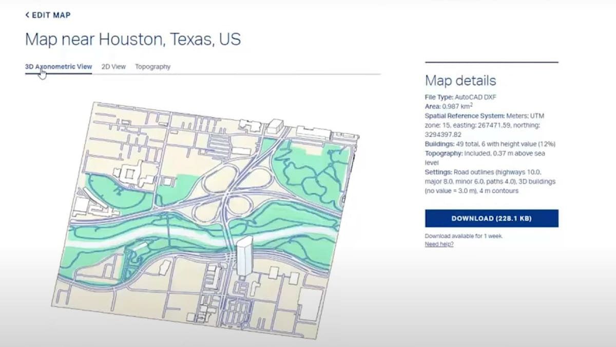
Mapacad
Mapacad is an online platform that offers 2D and 3D files for urban areas. The plans available cover entire city areas and are available as a single purchase.
The website is focused on DWG files for architects and designers. Each city plan has at least 27 information layers, including streets, city blocks, and natural borders like rivers or coastlines.
3D models are limited to a few selected cities and can cost up to $25 each. For the 2D files, prices range between $5 to $15, and in case the city you’re looking for isn’t there, they also offer an on-demand service to create it.
- Type: 2D and 3D map
- Export options: DWG (2D), OBJ (3D)
- Prices: $5-$25
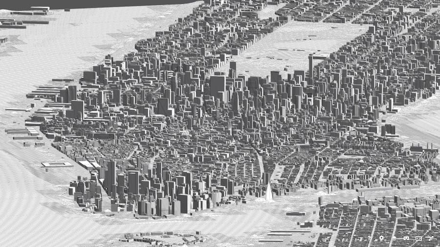
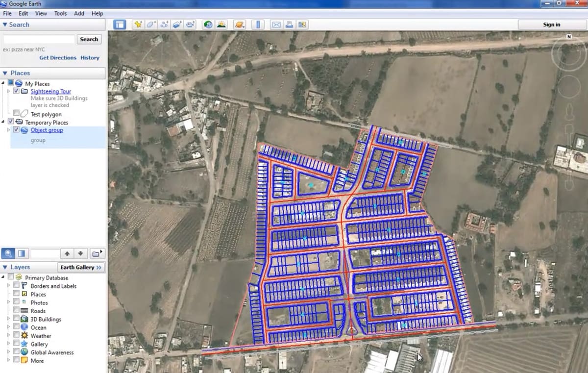
Cadmapper
Similar to Mapacad, Cadmapper also works with 2D and 3D models of urban areas. However, it allows the user to pick and choose a squared area of the map and prices are proportional to the area size.
It’s a very straightforward process: you pick the area of interest, decide whether to include topography, 3D building information (if available), then select the design software or CAD format you’d like to export the file as.
Cadmapper offers over 200 entire city plans in DXF free to download, while the custom selection is free for areas up to 1 km². 3D file formats available for export include Rhino3D (.3DM) and SketchUp (.skp), but no mesh formats like STL or OBJ.
- Type: 2D and 3D map
- Export options: DXF, AI, DWG (2D) and 3DM, SKP (3D)
- Price: Free up to 1 km², then pricing proportional to the selected area
AutoCAD – Map 3D Toolset
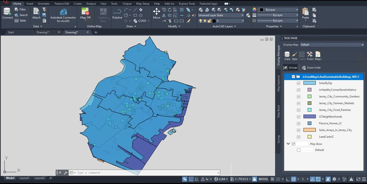
Considered to be one of the most industry-defining CAD programs of all time, AutoCAD has a specific toolset for importing and working with maps.
Known as AutoCAD Map 3D, it was a standalone program until it was incorporated into the standard AutoCAD software. Now, users can get and edit map layouts without ever leaving their CAD program.
The Map 3D toolset can also work with 3D information from cloud points and lidar data, enabling quick and precise topology analysis and drawings to be created. Architects should have a field day with it.
- Type: 2D and 3D
- Export options: Built-in tool included with AutoCAD
- Price: ~$1,955/year
CAD-Earth
CAD-Earth is a multi-purpose tool for all things geospatial. It’s plug-in software that basically acts as an interface between Google Earth and AutoCAD, Civil 3D, and BricsCAD.
One of its core functionalities is to import and export CAD objects to and from Google Earth, including terrain mesh data. Georeferencing also plays a central role in CAD-Earth, allowing the precise placing of drawings onto a map.
CAD-Earth is a paid software tool with many licensing options, ranging from yearly subscriptions starting at about $150 to permanent licenses starting around $270.
- Type: 2D and 3D
- Export options: Plug-in tool for AutoCAD, Civil 3D, and BricsCAD
- Price: $150-$350 for annual licenses, $270-$630 for permanent licenses
OpenTopography
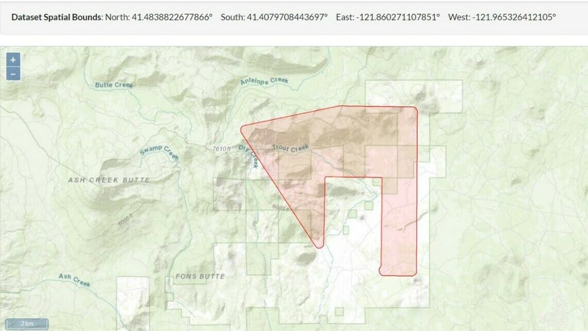
OpenTopography is a provider of free high-resolution topographic data, as well as associated tools and services. The OpenTopography Portal is accessible without the need for any software other than a web browser, although the team behind it offers its open-source software tools to all on GitHub.
DEMs and point cloud data are the main geospatial resources that users will find on OpenTopography. These extensive datasets serve as a valuable asset for examining landscape characteristics, conducting geomorphic research, and generating precise topographic visualizations.
The availability of certain datasets can, however, vary based on many factors, namely data sources, area, as well as data pooling agreements. Lidar data, satellite-derived DEMs, and aerial photogrammetry datasets are among those that are readily available on the website. Certain datasets could be subject to limitations because of license agreements, data ownership issues, or privacy concerns.
OpenTopography offers downloadable DEM files in compatible formats, like GeoTIFF or ASCII. These files can even be processed and converted into 3D printable files using software like ArcGIS, MeshLab, Blender, among other tools. The FAQ page offers a lot of guidance on supported file formats and conversion opportunities.
- Types: 2D and 3D
- Export options: GeoTIFF, IMG, KMZ, ASCII, LAS, LAZ, among others
- Price: Free
License: The text of "Cadmapper & 6 Alternatives (Some are Free)" by All3DP is licensed under a Creative Commons Attribution 4.0 International License.